
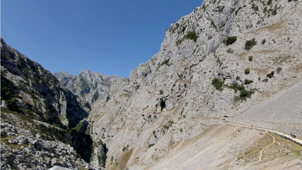
Route description: Poncebos , Cain, Posada de Valdeón
Option 1: Complete Route (North-South Traverse)
- Type: Linear / Traverse (Poncebos ->Posada de Valdeón).
- Distance and Duration: 21 km (approx.) / 6 hours and 30 minutes (one way).
- Level: +1,000 m accumulated ascent (starting at 200 m, climbing to 500 m at Los Collaos, descending and finishing at 939 m in Posada).
- Difficulty: Medium / High (mainly because of the length and physical effort)
Option 2: The Classic (Roundtrip to Cain)
This option uses only the first part of your text (points 1, 2 and 3) and adds the return by the same route.
- Type: Roundtrip (Poncebos ↔ Cain).
- Distance and Duration: 24 km (12 km one way + 12 km return) / 6 to 7 hours (total).
- Level: 600 m accumulated (approx). Los Collaos (500 m) is climbed twice, once on the outward and once on the return.
- Difficulty: Medium.
The main milestones of this route are described below, ready to choose the desired option
1. From Poncebos to Los Collaos (The initial ascent)
The starting point is Poncebos Bridge (altitude 200 m). We cross the streams of La Trapa, Bárcena and La Valuga and go through a tunnel following the road. In a few minutes, we leave on our left the path of the PR-19 and GR-202 that crosses the bridge of La Jaya towards the Canal del Tejo and the village of Bulnes.
We continue ascending along the main path. We will pass through the Rexes sheepfold, the Correntía de los Argaos and the Silaspeñas spot, leaving aside the ruins of the barracks used during the construction of the canal. The trail gains altitude rapidly through the collau Peyucu until reaching Los Collaos (5 hours from the reverse start / altitude 500 m). Here, the path meets the route of the water channel, which at this point came running underground from the Camarmeña dam.
2. From Los Collaos to Culiembro
From Los Collaos, we descend slightly and begin to enter the gorge. We leave behind places like La Sota and the base of El Farfáu (an important spring of water coming from the Central Massif). We pass the mouth of the Sabugo channel (or La Viña) and the Raya channel.
Halfway through the gorge we reach the spot of Culiembro (altitude 340 m), where two huts of an old farmhouse are preserved. Here, on the right according to our direction of march, joins the GR-202 (Ruta de la Reconquista) that descends from the Canal de Culiembro.
3. From Culiembro to Cain (La Garganta Divina)
We advance towards the most spectacular area. We reach the "Pasarela de Los Martínez", an engineering work inaugurated in 2012 after a landslide, which allows us to see the emptiness under our feet thanks to its grid floor.
Shortly after (about 20 minutes), we cross the Bolín Bridge towards the slope of the Western Massif (El Cornión); from here the ascent of the Trea channel to Vega de Ario starts. Further on, we cross the Puente de los Rebecos to return to the slope of the Central Massif (Los Urrieles). In this section, the path is dug halfway into the rock and the closeness between the massifs is maximum, making it difficult to see the sky.
We continue accompanied by the water channel, crossing several of its 71 hand-dug tunnels, until we reach the Casielles irrigation (with views of the Dobresengos Canal on the other side). We enter the area known as the "Garganta Divina", cross the Puente de la Presa and pass the final tunnels that leave us at the houses of Los Pinteros. Finally, we cross the bridge to the right bank to enter the village of Caín (altitude 505 m).
In the square of Caín we can see the monument to Gregorio Pérez, "El Cainejo", first conqueror of the Naranjo de Bulnes. Here culminates the most spectacular part of the gorge, just about halfway through the route. One option is to retrace our steps and return to Poncebo. The other is to continue to Posada de Valdeón
4. From Cain to Chorco de los Lobos
We leave Cain by the road, cross the bridge of La Jarda over the Cares and ascend by a path to Collada del Pando. From there, we descend to cross the Puente de Piedra and then the Canceles bridge.
We continue along the road, exercising extreme caution due to vehicle traffic during the holiday season. We cross the bridge over the Cares and pass through the Santijan and La Peguera wintering grounds, enjoying views of the western massif and the Capozo channel. The trail crosses a mixed forest and meadows until we reach the Chapel of the Virgin of Corona, patron saint of the valley (where tradition places the coronation of Don Pelayo).
Approximately 150 meters later, we find the detour to the Chorco de los Lobos (altitude 760 m), a historic wolf hunting trap documented since 1610.
5. From Chorco to Posada de Valdeón
We return to the wintering grounds of Sésanes. After briefly linking up with the paved road, we take a path that climbs, crosses a wooden footbridge and passes next to the Teja Oscura fountain.
On the right side of the road (in our direction of ascent), we can visit the medieval necropolis of Barrejo (13th century). We continue ascending until crossing the road and arriving, after the profile of summits, to the Mirador del Tombo (altitude 830 m). Here the sculpture of the chamois by José Luis Alonso Coomonte and the views of the Central Massif stand out.
We cross the road again and take a path that leads us to a beautiful view of the village of Cordiñanes. The road continues south through mowed meadows to the Recreational Area of the Vega Boyán reservoir. We skirt the reservoir and follow the Bustio path beside the river. Finally, we cross the bridge over the Cares River and go up El Salvador Street until we reach the Town Hall of Posada de Valdeón (altitude 939 m), the end point of our route.
Posada de Valdeón (altitude 939 m), the end point of our route.